Drainage basins divide the Earth's land into individual water collection units. The geometric shape of rivers and basins affects the permeability of water and sediment, as well as the connectivity of freshwater species between ecosystems. For example, the shape of a basin determines the length of groundwater pathways, thus affecting the distribution and transport of nutrients and pollutants. Basin shape also determines landscape types, such as narrow river valleys or broad floodplains, which in turn affect habitat distribution and biodiversity.
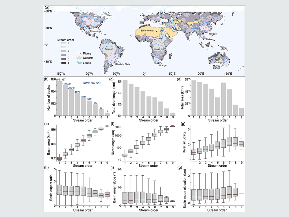
Assistant Professor Ci-Jian Yang from the Department of Geography at National Taiwan University collaborated with an international research team to extract 670,000 basins from a global digital elevation model using supercomputers. Each basin contains eight shape parameters, including main stream length, average slope, and terrain roughness. Spatially, there are interesting clustering phenomena in shape parameters. For instance, basins surrounding the Qinghai-Tibet Plateau often have elongated shapes, suggesting that basin shapes record traces of climate and tectonic activities. Additionally, the study used this database to examine classic terrain laws - Hack's Law and Horton's Law. Hack's Law describes an empirical formula between basin area (A) and river length (L). The correlation coefficient between the lengths of 670,000 basins and their main rivers is 0.97, indicating that basins and main rivers may co-evolve. Therefore, the global-scale Hack's Law is updated to L=2.1A^0.54. Horton's Law defines rivers hierarchically, with the number of rivers decreasing geometrically with increasing stream order. The ratio of the number of adjacent rivers between two stream orders is defined as the bifurcation ratio, which ranges from 4.26 to 4.42 at the global scale in this study. With the largest global basin database to date, the research team hopes to provide scientists with more data choices for related research.
The research data, programs, and analysis results, titled "A global dataset of the shape of drainage systems," are published in Earth System Science Data. The study was jointly completed by research institutions such as Massachusetts Institute of Technology, National Taiwan University, and the German Research Centre for Geosciences.
Full text of the research: https://doi.org/10.5194/essd-16-1151-2024
來源: https://www.ntu.edu.tw/spotlight/2024/2247_20240320.html